
Citizens’ smartphones can be used to create highly detailed site amplification maps for earthquakes, a breakthrough study reveals. The research, published in Nature Communications, demonstrates how thousands of measurements from phones’ built-in accelerometers can map how local geology amplifies shaking, achieving a level of detail that surpasses what traditional seismic stations alone can provide.
This high-resolution mapping is crucial for understanding which areas and buildings are at higher risk during seismic events. The study was conducted by Prof. Dr Francesco Finazzi (University of Bergamo, Italy), Prof. Dr Fabrice Cotton (GFZ Helmholtz Centre for Geosciences, Germany), and Dr Rémy Bossu (European-Mediterranean Seismological Centre, France).
Their novel approach builds on the Earthquake Network (EQN), a citizen science initiative launched in 2013. While smartphones can detect shaking, their individual readings are noisy and influenced by factors such as buildings and device location. The authors applied a spatial statistical model to average out these effects and fuse the data with records from traditional seismological stations.
High-risk zones
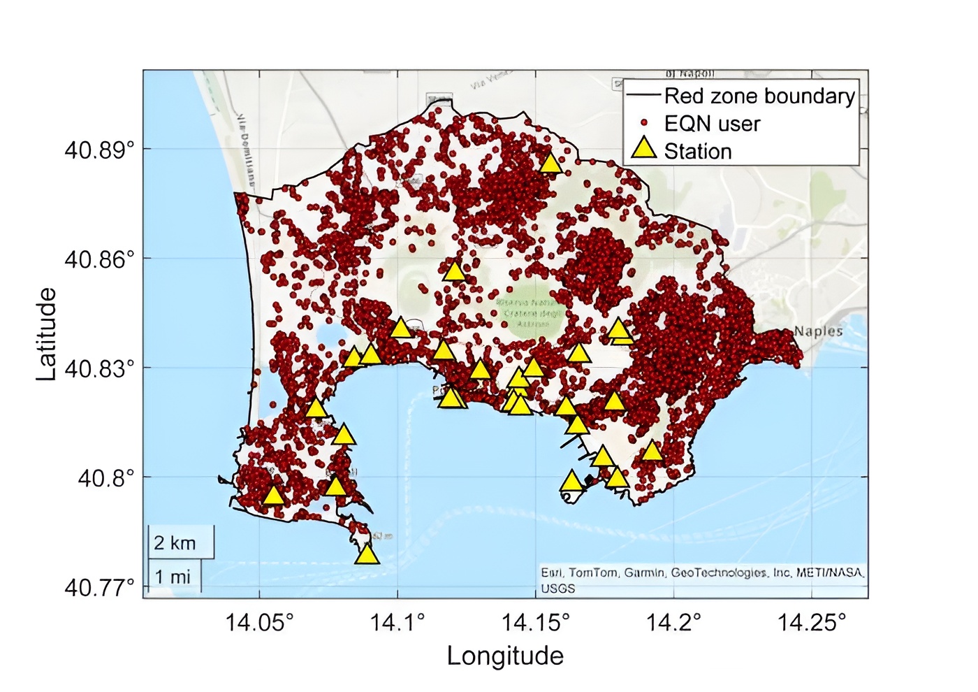
The team tested the approach in the Campi Flegrei region near Naples, Italy, a high-risk volcanic and seismic zone. Between 7,000 and 9,000 residents in the “red zone” actively contributed data via EQN, compared to only 29 traditional seismic stations in the same area.
“The EQN smartphone network is of high density and covers areas of the red zone where no stations are installed. This allows the variability of the ground shaking to be captured at a higher spatial resolution over the entire red zone,” explains Francesco Finazzi, first author of the study.
The analysis produced the first high-resolution amplification map of the area, showing amplification varied significantly over just 10 km. This data can be used to generate high-resolution “ShakeMaps,” which are essential tools for guiding rescue teams and organising emergency responses.
“With urban populations growing worldwide and the urgent need for high-resolution ShakeMaps, this study shows that combining citizens’ smartphone accelerometer data with seismic network observations enables the generation of site-specific, high-resolution ShakeMaps in densely populated urban areas. This improves the characterisation of ground motion in the built environment, where seismic risk is concentrated”, summarises co-author Prof. Dr Fabrice Cotton, Head of GFZ-Section 2.6 “Seismic Hazard and Risk Dynamics”.